The DTNA Land Use and General Meetings in December saw record participation as Professor Lamb and three graduate student groups from UC Berkeley ’s College of Environmental Design presented their community research findings for our Vision - Slow Triangle (see earlier newsletters for more details on that).
The teams had been instructed to use methods that broadly reflect the diverse perspectives of our community: they conducted interviews with residents, merchants, and visitors - randomly, with a survey stand at our Phoenix Day block party, and via direct outreach to ensure minority representation. Students also spent countless days in the Triangle observing behavior, such as counting people jaywalking or vehicles running stop-signs. Finally, they accessed secondary data, including traffic statistics provided by Uber and records in the city archives.
Here are a few snippets of what they found:
Parking configurations: Students saw evidence that vehicles parked at intersections obstructing visibility cause a higher incidence of cars running stop signs and pedestrians hesitating to cross. A comparison of different parking configurations (parallel, perpendicular, angled) showed that angled parking increases perceived pedestrian safety and therefore encourages jaywalking (leaving aside aspects of desirability or legality for a moment). Their recommendations included selective removal of parking spaces at critical intersections (Duboce & Sanchez, 14th & Sanchez, 14th & Noe, 16th & Castro) to improve pedestrian safety.
Streetside mini-plaza design: This group found a positive impact of vegetation, slow traffic, and wood (instead of stone) seating on increased resident use of our corner bulb-outs. The group suggested that gathering spaces need better upkeep and can be designed to cater to different users (e.g. visitors vs. residents) with different functions (e.g. social vs. quiet activities).
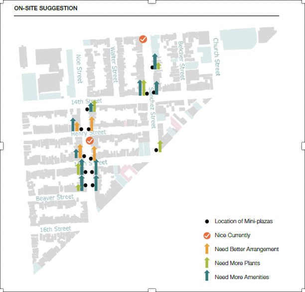
UC Berkeley Masters of Urban Planning studied the mini-plazas mapped above. Two were found to be “nice currently”, the rest need various upgrades for different uses.
Sidewalk activation: This group researched how sidewalk safety and walkability influence the desire of pedestrians to use certain streets. They highlighted the challenges pedestrians face on 14th Street, given unusually narrow sidewalks and a very uncomfortable intersection at Sanchez and Noe. Recommendations included sidewalk widening and traffic slowing measures, such as chicanes and center islands.
Full copies of their research reports are available upon request, and minutes of the meeting summarizing community feedback are available on the DTNA website.
It was clearly a privilege to have mid-career urban design professionals in one of the world ’s best urban design programs generously study our small corner of this planet. Their outside perspectives highlighted issues that most of us have stopped actively seeing and proposed fresh ideas to address them.
As a community, it now rests upon us to act and decide on the desirability of their recommendations. We want to hear from you and involve you in the process of making the Vision - Slow Triangle a reality, translating these findings into design guidelines and budget requests to policy makers and city departments. Please contact us at landuse@dtna.org
The final research report can be viewed here